Some might remember the episode when Top Gear sets out to find the greatest road in the world (season 10, episode 1) and finds that stretch of road from Davos in Switzerland to the Stelvio Pass in Italy.
Well, since it's only a 200km trip from where I live and with the weather being perfect last weekend, I thought I'd find out for myself on how it stacks up against some of the other great passes here in Switzerland.
Here's how it turned out:
We set off at around 2.30 p.m. from Zurich on the autobahn towards the Alps and got off in Landquart where we then took the public road up to Davos (which is where the yearly world economics forum [WEF] take place). Davos is at 1560m the highest city in Europe and surrounded by national park as well as offering high quality skiing in winter. It is also where the first pass, the Flüelapass, starts that leads into the Engadin valley which is where we would be heading to find Stelvio but where other popular places like St. Moritz are located as well.
Picture from on top of the Flüelapass, roughly at 2380m height.

After the Flüelapass we arrived in Susch and from there headed further south-east towards our next destination, the Ofenpass. The Ofenpass offers some nice driving as well and from there we took the Umbrailpass over the mountain and out of Switzerland and into Stelvio territory. After crossing the border into Italy, the summit of the Stelvio Pass is only another 3km up the hill.
And there we were - top of the Stelvio pass at 2753m (which is the alps second highest paved mountain pass), looking down at a stretch of road with countless hairpins (48 in total on that side right to the bottom):

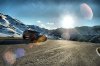
Then on the way down some more pictures:

...Me posing

Then once we hit the bottom, we turned around to make our way back up the pass again (since it was already after 6 p.m we slowly had to make our way back home) we took some more pictures:


Oops - hit the picture limit - next few pictures will follow in the next post.
Well, since it's only a 200km trip from where I live and with the weather being perfect last weekend, I thought I'd find out for myself on how it stacks up against some of the other great passes here in Switzerland.
Here's how it turned out:
We set off at around 2.30 p.m. from Zurich on the autobahn towards the Alps and got off in Landquart where we then took the public road up to Davos (which is where the yearly world economics forum [WEF] take place). Davos is at 1560m the highest city in Europe and surrounded by national park as well as offering high quality skiing in winter. It is also where the first pass, the Flüelapass, starts that leads into the Engadin valley which is where we would be heading to find Stelvio but where other popular places like St. Moritz are located as well.
Picture from on top of the Flüelapass, roughly at 2380m height.
After the Flüelapass we arrived in Susch and from there headed further south-east towards our next destination, the Ofenpass. The Ofenpass offers some nice driving as well and from there we took the Umbrailpass over the mountain and out of Switzerland and into Stelvio territory. After crossing the border into Italy, the summit of the Stelvio Pass is only another 3km up the hill.
And there we were - top of the Stelvio pass at 2753m (which is the alps second highest paved mountain pass), looking down at a stretch of road with countless hairpins (48 in total on that side right to the bottom):
Then on the way down some more pictures:
...Me posing
Then once we hit the bottom, we turned around to make our way back up the pass again (since it was already after 6 p.m we slowly had to make our way back home) we took some more pictures:
Oops - hit the picture limit - next few pictures will follow in the next post.
Last edited by a moderator: